
SED 695B; Fall 2005
Directions:
Corriganville
7001 Smith Road
Simi Valley, CA
-
From Moorpark:
-
Take the 118 Freeway East towards Simi Valley
-
Exit on Kuehner, Turn Right, go 1.1 miles
-
Turn Left on Smith Road, go 0.4 miles
-
Corriganville is at the end of Smith Road on the left.
-
From San Fernando Valley:
-
Take the 118 Freeway West towards Simi Valley
-
Exit on Kuehner, Turn Left, go 1.1 miles
-
Turn Left on Smith Road, go 0.4 miles
-
Corriganville is at the end of Smith Road on the left.

Topics addressed:
Botany
Geology
Zoology
History
Description of Field
Trip
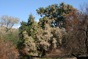
An observational study of the trail through the chaparral in
Corriganville, Simi Valley.
Including a look at flora, fauna, geology, and history of the park.
Along with
evidence of the floral recovery of the area from two fires
which occurred two years apart - one in the fall of 2003,
the second in the fall of 2005.
The Trail
Begin at the northeast end of the parking lot, at the information kiosk. Follow the trail as indicated on the map to the right. There are interpretive trail markers along the way until you reach the farthest point (marker # 10) before turning west. Continue up the hill, making the observations below. Take the middle trail down the hill. After going up the next hill, and reaching the farthest point west, turn and go down the hill past the movie lots, in a south-easterly direction. Stay to your left and pick up the last part of the interpretive trail markers (#20) and following them back east before reaching the end (Marker # 12) at the bridge across the concrete pool.

Questions:
1) List the typical flora of the area.
2)
What types of biomes are present?
3) Find evidence of re growth in the burned areas, how did the surviving plants re grow?
4)
What types of plants do you find growing in the recovering burned areas? Do not count the sycamores planted by the park district in the overnight area?
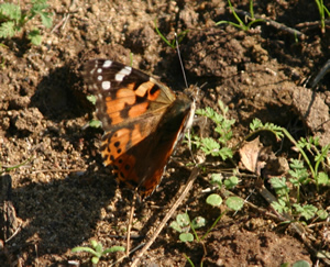
5) List any animals you see, hear or find evidence of (nests, tracks, scat).
6) Discuss the geology of Corriganville.

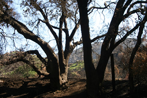
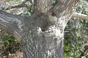
Marker # 1 "Coast Live Oak". Many of these trees, Quercus agrifolia, have been damaged in the fires. Normally they stay green all year round. The tree is easily identified from its gray, smooth bark and holly-shaped leaves.
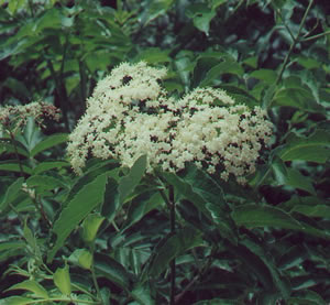
Marker #2 "Elderberry". The bushes at this marker appear to have been devastated in the fires. They normally contain clusters of blue-black berries with white flowers.
Marker # 3 "Railroad Tunnel Mound". (Not shown see HISTORY page.)

Marker #4 "Decomposing Trunk". The action of tiny insects and fungi add nutrients to the soil.

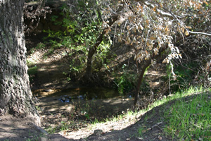
Marker #5 ""Willows". These trees, Salix spp. grow in riparian areas. They contain the same chemical as found in aspirin.

As you pass Markers #6-8 (not shown) look for survival and re growth of plants from the fires.
Markers # 6-8 can be found on the HISTORY page.

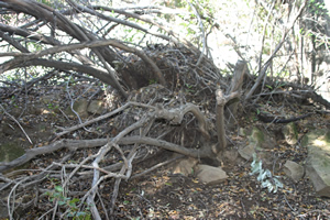
Marker # 9 "Fallen Oak". This tree, on the first part of the trail heading northeast, shows a coastal live oak that fell over in the winter storms of 1995 due to heavy winds. How did the plant adapt to its new position?
Markers # 10 & 11 can be found on the HISTORY Page.
The suggested trail for this field study goes to the northeast end of the concrete pool, and then turns northwest and heads up the hill. The trail to follow is called "The Loop Trail".
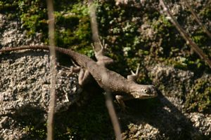
Look for animals, or evidence of animals.
There are many birds which frequent the area.
Look in the soft soil, besides the tracks left by dogs, what can you find?

Past the area that the park district has replanted with sycamore trees, you can find sumac or sugar bush, Rhus ovata, in the hills towards the north (right) as you hike up the hill.
What other types of plants do you see?
Look closely.

As you reach the top of the hill, continue west, take the middle trail down to the bottom, then turn left and go up a small hill.
Continue to look for evidence of fire survival.

Soon you will find markers (not numbered) which describe areas used in movie sets.
See HISTORY page.
Shown here is a chaparral yucca, Hesperoyucca whipplei.
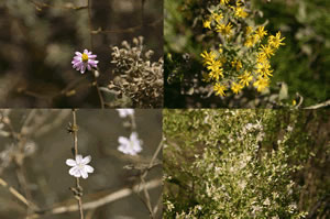
There are numerous wildflowers along the way.
A few are shown here.
As you travel around the hill, and keeping to the left, you will pass the movie sets and pick up the interpretive trail markers at the end.
Continue back up the trail from Marker # 20 to Marker # 12.
Marker # 20 "Valley Oak". This type of tree, Quercus lobata, can live to be hundreds of years old and loses its leaves in the winter. Galls can be found on the stems of the tress formed from wasps laying eggs in the trees.
Marker #19 is not shown, see HISTORY page.
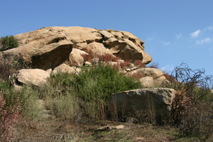


Marker # 12 "Caves (Rock Shelter)". These are natural formations in the sandstone.
The trail at this point comes back to the "Concrete Pool" where many movies were filmed. See HISTORY Page.

Cross the bridge and you are on the first part of the trail, head west back to the parking lot.
References & Links:
Corriganville Hiking Trails:
http://www.latrails.com/hike/co.html
Marker List Originated From:
- Rancho Simi Recreation and Park District
Sycamore Drive Community Center
1692 Sycamore Drive
Simi Valley, CA 93065 - 805-584-4400
http://www.rsrpd.org/parkmap.htm
http://www.rsrpd.org/Corriganville.htm
Blue Planet Chaparral:
http://www.blueplanetbiomes.org/calif_chaparral.htm
Maps from:
Terraserver-usa topographical map
Belzer, Thomas J. (1984) Roadside plants of southern california (9th ed.). Missoula: Mountain Press Publishing.
Halsey, Richard W. (2005) Fire, chaparral, and survival in southern california (1st ed.). San Diego: Sunbelt Publications.
Stone, Robert (2003) Day hikes around ventura county (2nd ed.). Red Lodge, Montana: Day Hike Books.
http://www.localhikes.com/Hikes/Corriganville_4472.asp
Stuart, John D. & Sawyer, John O. (2001) Trees and shrubs of california (1997). Berkeley and Los Angeles: University of California Press.